Dynamic Outer Banks “Hot Spots”
The Outer Banks is a remarkably dynamic place with immense sandbars that rise above sea level. Because of this fact, the force of the wind and sea can have a dramatic impact on the shoreline. Yet the majority of the Outer Banks remains stable. Some of this stability is a result of geography or nature; other secure areas are the result of human intervention including South Nags Head’s recent success with beach nourishment.
However, there are some areas that are currently active, and are referred to as “hot spots.” Consistent steps are taken to stabilize these more dynamic areas.
Duck – North of the Army Corps of Engineers Research Pier
At one time there was a Lifesaving Station in the same location as the Sanderling Resort. The station was called Caffey’s Inlet and was the site of inlet that closed in the early 20th century. The Outer Banks is quite narrow in this area and the wave action is particularly strong on the north end of the town. Concerns about beach erosion in this zone is one reason the town of Duck entered into an inter-local agreement with Dare County to nourish its beaches.
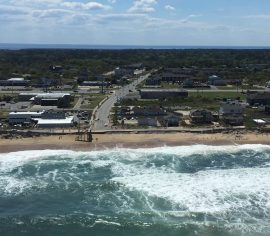 Kitty Hawk – NC-12 between Kitty Hawk Road and Lillian Street
An area of recent concern is this segment of the Beach Road because the Atlantic Ocean is close to encroaching in a populated, developed area. Repair crews are currently fixing damage done in late September and early October by a series of storm systems, which is the same area repaired over the summer. Like the town of Duck, Kitty Hawk has entered into an inter-local agreement to fund beach nourishment with Dare County.
An interesting piece of geographic history helps to explain the cause. The sea encroachment is in the center of what was once a river bed, the Albemarle River, which still exists. About 20,000 years ago at the end of the last ice age, the sea level was much lower (approximately 400 feet) and the Albemarle River carved a deep channel through Kitty Hawk. That is why the sand on the beach at the south end of town is coarser than the fine grained sand found in Corolla.
S Curves Pea Island National Wildlife Refuge, North of Rodanthe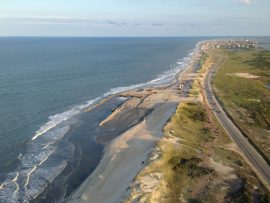
The forces that create some of the best surfing on the East Coast at the S Curves are the same forces that will ultimately force a breach in the shoreline. Water flowing around Wimble Shoals at Rodanthe is funneled into the S Curves.
This is an area that is historically prone to severe ocean over wash and road damage. During Hurricane Irene an inlet formed here although it was shallow and was quickly filled in. NCDOT, working with the US Fish and Wildlife, nourished this stretch of road last year. When the Beach Road in Kitty Hawk was undercut by wave action, and Buxton had waves breaking through on the north end of town, the S curve dunes held and there has been no over wash.
North End of Buxton
A series of storms demonstrated how prone the north end of Buxton on Hatteras Island is to the forces of the sea. Diamond Shoal conditions are almost identical to what caused the S curve problems, although the current level of sea encroachment is a recent phenomenon.
Buxton is an unincorporated part of Dare County so maintenance is the county’s responsibility. The National Park Service, who owns the beach, and the county are working together to develop an expedited permitting process for beach nourishment that will hopefully begin this summer.